Universities across the APPA regions have started to implement unmanned aerial vehicles (UAVs), also known as drones, to inspect facilities infrastructure. No more than five years ago, universities were paying for helicopters to capture images of their campus. Today, some universities have their own fleet of drones to oversee their facilities. The cost of equipment has dramatically lowered due to an influx of commercial drone manufacturers, which allows them to be considered for purchase.
Along with the cost reduction, the Federal Aviation Administration (FAA ) has provided clear guidance for flight operations and has put in place license requirements and rules of operation. This opens the door for inspections by air, without the need of a helicopter.
In-House vs. Outsourcing
When considering the use of drones at your institution, the first question to ask is whether the university purchases the drones and completes the flights, or if it is better to outsource these activities. Purchasing equipment and obtaining the certifications require an initial investment. This cost is determined on the goals for the drone program. The price of a drone is between $1,500 and $40,000, but the payload (camera) can range from $1,200 to $250,000, with Lidar (light detection and ranging) cameras being the most expensive option and thermal cameras ranging between $5,000 and $18,000. Specialty cameras (natural gas detection, normalized difference vegetation index [NDVI]) have a wide range in price. In addition to drone/camera cost, the insurance, software, and drone pilot add to the overall expense. Outsourcing cost is based on hourly rate or the overall project. The hourly rates can range from $175 to $500 per hour depending on mission and type of drone/camera being used on the project. Lidar costs are usually calculated by project and not hourly rates, due to the price of equipment.
One consideration is to partner with academic groups that are utilizing drones; this allows them to collect facilities data for the classroom as well as provide the university with useful and needed data. This collaboration could be a win-win for both groups.
Productive and Beneficial Use of Drones on Campus
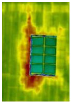
Case 1
Thermal Roof Inspection Drones allow for quick identification of anomalies on a roof, especially the water intrusion of a roof membrane. Wet subsurface material will retain heat after the sun has set, enabling a thermal camera to detect potential areas for further inspection. Image capture during the night is needed for accurate analysis. Night flights do require anti-collision lights, which can be seen for up to 3 miles, and new FAA regulations provide increased flexibility to conduct certain small drone opera-tions without obtaining a waiver.
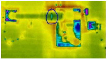
Case 2
Inspection of Equipment Areas of equipment that are hard to access due to location are now easily accessible with a drone. These issues could go unnoticed for years but are quickly detected with a drone. Finding areas where a university is losing cold/hot air is vital for energy savings and sustainability. Consider the amount of energy loss from leaking window seals, which could be identified and fixed due to drone images.
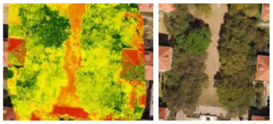
Case 3
Inspection of Tree Canopy on Campus Drones allows you to locate tree damage from storms and animals at a safe height, access the overall health of trees on campus, and provide images of the tree canopy to use for future building expansion, which could impact the trees around the project.
Adding in NDVI allows for more detailed analysis of trees and plants on campus, which means being able to see is-sues before they become visible to the human eye.
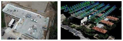
Case 4
Project Update Drones enable photographing project construction from different viewpoints around the site, as well as the ability to create a 360-degree image above a site for quick reference during project meetings, and a point cloud of the site to use in construction documentation.
Case 5
Confined Space Inspection. Using drones, areas that require specific safety equipment for employee access can be inspected without needing to put anyone in an unsafe environment. Water storage tanks, manholes, large-size pipes, power plants, etc., are all potential areas where this type of drone can be used.
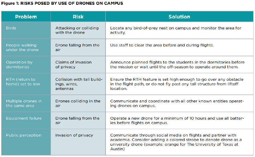
Risks Posed by Use of Drones on Campus
Understanding the potential risks is vital before deciding to use drones on campus. A drone falling out of the air and injuring a student, faculty member, or individual on campus is not acceptable. Proper planning and training will lower the chances of this happening, but nothing is guaranteed.
FAA Regulations
The FAA has recently updated the regulations on drones (https://www.faa.gov/uas/commercial_operators/) and still mandates that a drone pilot is required to have their 107 certificate from the FAA (unless the drone is used for research (https://www.faa.gov/uas/educational_users/). New rules allow for flights over people, operation at night without needing a waiver (unless in specific air spaces), and flights from a moving vehicle. There are several online classes that will prepare employees for the 107 test, which is simple if you have any knowledge of flying. Failure to comply with FAA regulations can result in fines; for example, operation without a license is $10,000 per occurrence. In addition to FAA regulations, universities have created drone policies that could impact your ability to operate. A sample drone policy can be found at https://policies.utexas.edu/policies/ unmanned-aerial-vehicles.
The FAA updates policies to match the operations of drones in the United States. It is recommended that universities continuously check for new policies.
Conculsion
Drones are a new tool that can be utilized for process improvements on campus. As with any new tool, training and practice is vital. Discussions will be needed with different groups on campus before deciding on a direction, especially with the risk management department. Aspects to keep in mind are air space over the university, funding, weather, and whether it would be a lower cost to outsource. The process can be daunting, but there are groups that can assist you, along with guidance from the FAA. APPA is about collaboration, so if your university decides to go in this direction, feel free to reach out to me and others that have gone through the process.
Reprinted with permission from APPA’s July/August 2021 Facilities Manager magazine. Markus Hogue is senior GIS analyst at The University of Texas at Austin and current CAPPA President. markus.hogue@austin.utexas.edu